Severe Weather

44 Results / Page 5 of 5

Local News

SNOW DAY REPORT for 2/20/25

Brought to you by Wade A. Flowers, State Farm Agent Due to the road conditions on some of our back roads, possible snow in the forecast later this evening, and the cold weather advisory, there will be NO SCHOOL on February 20, 2025, for Taylor County School District. This will be a traditional “snow day,” and we will most likely have to make this day up at a later time. […]

todayFebruary 19, 2025 1

Local News

WINTER WEATHER ADVISORY

Brought to you by Wade A. Flowers, State Farm Agent. ...WINTER WEATHER ADVISORY REMAINS IN EFFECT FROM 3 PM CST /4 PM EST/ THIS AFTERNOON TO 6 AM CST /7 AM EST/ THURSDAY... WHAT...For the Winter Storm Warning, heavy snow. Total snow accumulations between 2 and 4 inches. For the Winter Weather Advisory, snow expected. Total snow accumulations up to one inch. WHERE...Portions of south central Indiana and east central, […]

todayFebruary 19, 2025 1

Local News

SNOW DAY REPORT FOR 2/19

Brought to you by Wade A. Flowers, State Farm Agent The Green County Public Library will be closed, Wednesday, February 19th. All items due will be renewed for another two weeks. Best Care Family Practice will be closed today (02-19-25) for in person appointments, but they will be seeing patients by telehealth. Crossroads Family Medicine will be closed today (2/19/25) due to weather. Based on the winter storm warning and […]

todayFebruary 18, 2025

Local News

COLD WEATHER ADVISORY

COLD WEATHER ADVISORY Brought to you by Wade A. Flowers, State Farm Agent. ...COLD WEATHER ADVISORY IN EFFECT FROM 1 AM EST/MIDNIGHT CST TO 11 AM EST/10 AM CST THURSDAY... WHAT... Very cold wind chills between 5 above to 5 below zero expected. WHERE... Portions of south central Indiana and east central, north central, northwest, and south central Kentucky. WHEN... From 1 AM EST/midnight CST to 11 AM EST/10 AM […]

todayFebruary 18, 2025

Local News

Tuesday AM Weather Update

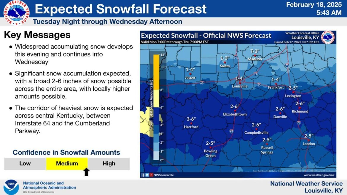
From the US National Weather Service - Louisville, KY A winter storm will bring significant snow accumulation to central and southern Kentucky Tuesday evening into Wednesday afternoon. Lighter snow accumulation is expected north of I-64. The heaviest snow will occur between 9 pm Tuesday and 5 am Wednesday.

todayFebruary 18, 2025

Local News

WINTER STORM WARNING

WINTER STORM WARNING Brought to you by Wade A. Flowers, State Farm Agent …WINTER STORM WARNING IN EFFECT FROM 6 PM CST/7 PM EST TUESDAY TO 11 AM CST/NOON EST WEDNESDAY... WHAT... Heavy snow expected. Total snow accumulations of 4 to 6 inches with locally higher amounts possible. WHERE... Portions of Indiana and east central, north central, northwest, and south central Kentucky. WHEN... From 6 PM CST/7 PM EST Tuesday […]

todayFebruary 18, 2025

Severe Weather

WINTER STORM WARNING

WINTER STORM WARNING Brought to you by Wade A. Flowers, State Farm Agent …WINTER STORM WARNING IN EFFECT FROM 6 PM CST/7 PM EST TUESDAY TO 11 AM CST/NOON EST WEDNESDAY... WHAT... Heavy snow expected. Total snow accumulations of 4 to 6 inches with locally higher amounts possible. WHERE... Portions of Indiana and east central, north central, northwest, and south central Kentucky. WHEN... From 6 PM CST/7 PM EST Tuesday […]

todayFebruary 18, 2025