









Severe Weather

44 Results / Page 1 of 5

Severe Weather

Frost Advisory

...FROST ADVISORY IN EFFECT FROM 1AM EDT/MIDNIGHT CDT/ TO 10AM EDT/9AM CDT/TUESDAY... * WHAT...Temperatures as low as 31 will result in frost formation. * WHERE...Portions of Indiana and east central, north central, and south central Kentucky. * WHEN...From 1 AM EDT/Midnight CDT to 10 AM EDT/9 AM CDT Tuesday. * IMPACTS...Frost could harm sensitive outdoor vegetation. Sensitive outdoor plants may be killed if left uncovered. PRECAUTIONARY/PREPAREDNESS ACTIONS... Take steps now […]

todayApril 6, 2026 1

Local News

Freeze Warning Issued Until Friday Morning

Freeze Warning issued October 23 at 2:45AM EDT until October 24 at 9:00AM EDT by NWS Louisville KY Description * WHAT...For the Frost Advisory, temperatures as low as 33 willresult in frost formation. For the Freeze Warning, sub-freezingtemperatures as low as 29 expected.* WHERE...Portions of south central Indiana and east central, northcentral, and south central Kentucky.* WHEN...For the Frost Advisory, until 9 AM EDT /8 AM CDT/ thismorning. For the […]

todayOctober 23, 2025 1

Severe Weather

Heat Advisory Remains In Effect

...HEAT ADVISORY REMAINS IN EFFECT UNTIL 8 PM EDT/7 PM CDT THISEVENING...* WHAT...Heat index values up to 105.* WHERE...Portions of southern Indiana and central Kentucky.* WHEN...Until 8 PM EDT /7 PM CDT this evening.* IMPACTS...Hot temperatures and high humidity may cause heat illnesses.PRECAUTIONARY/PREPAREDNESS ACTIONS...Drink plenty of fluids, stay in an air-conditioned room, stay out ofthe sun, and check up on relatives and neighbors.Take extra precautions when outside. Wear lightweight and […]

todayJuly 30, 2025 3

Severe Weather

Heat Advisory

…HEAT ADVISORY IN EFFECT UNTIL 8 PM EDT/7 PM CDT Wednesday... WHAT...Heat index values up to 106. WHERE...Portions of south central Indiana and east central, north central, northwest, and south central Kentucky. WHEN...Until 8 PM EDT /7 PM CDT Wednesday. IMPACTS...Hot temperatures and high humidity may cause heat illnesses.PRECAUTIONARY/PREPAREDNESS ACTIONS...Drink plenty of fluids, stay in an air-conditioned room, stay out ofthe sun, and check up on relatives and neighbors.Take extra […]

todayJune 23, 2025 2

Severe Weather

Severe Thunderstorm Warning

The National Weather Service in Louisville has issued a* Severe Thunderstorm Warning for... Southern Green County in central Kentucky... East central Barren County in south central Kentucky... Southwestern Adair County in south central Kentucky... Metcalfe County in south central Kentucky...* Until 1:30 PM CDT.* At 1:00 PM CDT, a severe thunderstorm was located 8 miles west of Edmonton, moving northeast at 30 mph. HAZARD...60 mph wind gusts and quarter size […]

todayJune 6, 2025 2

Local News

Tragedy in Washington County: Tornado Leaves Fatalities and Injured Residents

Early this morning, a tornado hit Washington County—as of 9:48am reports confirm one fatality and seven people injured. "As everyone already knows, southeastern Washington County was hit by a tornado this morning around 7 AM especially in the Long Run Road area. Every department in Washington County responded to coordinate a very difficult search and rescue mission. We had support from Marion, Nelson, Mercer, Boyle, and Woodford County’s with additional […]

todayMay 30, 2025 1

Severe Weather

Flood Watch

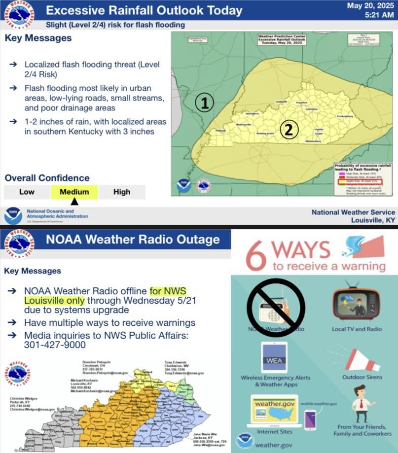
Ohio-Grayson-Hardin-Anderson-Woodford-Fayette-Bourbon-Nelson-Washington KY-Mercer-Jessamine-Clark KY-Larue-Marion-Boyle-Garrard-Madison-Butler-Edmonson-Hart-Green-Taylor-Casey-Lincoln-Logan-Warren-Simpson-Allen-Barren-Monroe-Metcalfe-Adair-Russell-Cumberland-Clinton Including the cities of Lebanon, Horse Cave, Greensburg, Hartford, Lexington, Nicholasville, Leitchfield, Bardstown, Campbellsville, Danville, Stanford, Richmond, Hodgenville, Columbia, Paris, Tompkinsville, Versailles, Lancaster, Bowling Green, Lawrenceburg, Franklin, Springfield, Liberty, Burkesville, Brownsville, Morgantown, Jamestown, Providence, Winchester, Russellville, Scottsville, Glasgow, Elizabethtown, Harrodsburg, Edmonton, and Albany ...FLOOD WATCH REMAINS IN EFFECT THROUGH LATE TONIGHT... * WHAT...Flooding caused by excessive rainfall continues to be possible. * WHERE...Portions of east central, north […]

todayMay 20, 2025 2

Local News

FLOOD WATCH

Severe Weather Coverage Brought to you by: Wade A. Flowers, State Farm Agent. Portions of east central, north central, northwest, and south central Kentucky, including the following areas, in east central Kentucky, Anderson, Boyle, Clark KY, Fayette, Garrard, Jessamine, Madison, Mercer and Woodford. In north central Kentucky, Hardin, Larue, Nelson and Washington KY. In northwest Kentucky, Ohio. In south central Kentucky, Adair, Allen, Barren, Butler, Casey, Clinton, Cumberland, Edmonson, Grayson, […]

todayMay 16, 2025 1